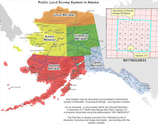
PLSS is set up by first establishing an initial points for a region. Most of the United States follows this system but the original thirteen colonies, Texas, parts of Florida, and a few other small locations. It is usually divided into 6-square mile townships and then townships are divided into 36 1-mile squares.
The site below also contains some great information about the PLSS process and maps to help gain a deeper understanding.
http://www.nationalatlas.gov/articles/boundaries/a_plss.html
No comments:
Post a Comment